|
Trip Report
BEHOLD! Cordillera Huayhuash (alpine circumnavigation)
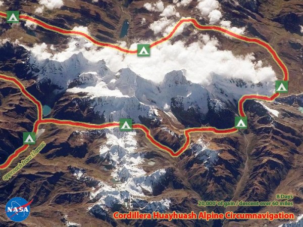
July 2013. Scott Berry and I completed Jeremy Frimer's alpine circumnavigation of the Cordillera Huayhash mountain range outside of Llamac, Peru. Over 8 days, we undertook what is quite possibly the best hike in the world. We made two glacier crossings, one rappel, and there is even some low 5th climbing near one of the passes. The route consists of approximately 20,000' of elevation gain and descent over 60 miles, crossing five 5500+ meter passes, and is the single most beautiful trip I've ever had the privilege of taking. More info on this trek can be found on Jeremy's website here: http://jeremyfrimer.wix.com/huayhuash-alpine [Click to View Linked Image] Brother and sister playing in the streets of Chiquián. [Click to View Linked Image] Our friends we shared a bus ride with from Chiquián to Llamac; the gateway to the HuayHuash. [Click to View Linked Image] Hiking out of Llamac. [Click to View Linked Image] First views of the range out of Llamac. [Click to View Linked Image] Yerupajá and Rasac bathing in the alpenglow. [Click to View Linked Image] Qonsti Casha is used in roof construction of adobe houses to create a lattice on which ceramic tiles are placed. [Click to View Linked Image] Mataji, and her offspring. [Click to View Linked Image] The Wamanpinta plant is boiled in water and used as a diuretic, more specifically for UTI's. [Click to View Linked Image] [Click to View Linked Image] The adventure begins! Heading for Rasac Punta after our first night at Jahuacocha, counterclockwise around the range. [Click to View Linked Image] Rasac Punta finally in sight now... [Click to View Linked Image] Qallu-qallu; qallu in Quechua means tongue; and is used as a remedy for heart pain. [Click to View Linked Image] [Click to View Linked Image] [Click to View Linked Image] Looking down Rasac Punta, the first pass. We crampon up, and set camp for the second night near the small lagoon in the photo. [Click to View Linked Image] [Click to View Linked Image] Alpenglow on Rasac Oeste. [Click to View Linked Image] Looking back on Rasac Punta and Rasac Oeste, on the morning of our third day. Jaeger solo'd the first ascent of Rasac Oeste up the obvious ramp. He then continued on to climb Rasac proper. [Click to View Linked Image] Numerous ice lines up the south face of Rasac from Quebrada Segya. [Click to View Linked Image] The route from Rasac Punta up the pass north of Rosario. [Click to View Linked Image] Nearing the pass... [Click to View Linked Image] [Click to View Linked Image] Carnicero shrouded in clouds. 5960 meters. [Click to View Linked Image] Yerupajá South Face, West Face of Siula Grande and Serapo [Click to View Linked Image] Looking back on our route from near our camp for the third night at Laguna Jurau. [Click to View Linked Image] Gaining the glacier above Laguna Jurau. [Click to View Linked Image] Scott applying friction. [Click to View Linked Image] [Click to View Linked Image] [Click to View Linked Image] [Click to View Linked Image] Jurau D, E and F. 5500+ meters [Click to View Linked Image] Passing through Trapecio Punta. [Click to View Linked Image] [Click to View Linked Image] Our camp for the fourth night below the West Face of Trapecio. 5653 meters. [Click to View Linked Image] [Click to View Linked Image] South Face of Trapecio. Alex Lowe solo'd a vertical ice flow up the right side of this face. [Click to View Linked Image] Nevados Jurau from the south. Departing from the Valley Circuit... gunning for Siula Pass where we spend our fifth night. [Click to View Linked Image] [Click to View Linked Image] Siula Grande's East Face from Siula Pass. [Click to View Linked Image] [Click to View Linked Image] Yerupajá East Face from Siula Pass. Messner climbed a new route on this aspect in 1969. [Click to View Linked Image] Yerupajá's flutings. [Click to View Linked Image] Yerupajá Chico and Jirishanca. [Click to View Linked Image] Dropping below Siula Pass. [Click to View Linked Image] [Click to View Linked Image] [Click to View Linked Image] [Click to View Linked Image] Jirishanca Chico from the Jirishanca base camp. [Click to View Linked Image] Jirishanca. [Click to View Linked Image] [Click to View Linked Image] From the pass east of Jirishanca Chico. [Click to View Linked Image] Alcaycocha. 4670 meters. [Click to View Linked Image] The route begins to arc to the west around Jirishanca Chico out to this hanging valley. The locals had trapped a herd of "wild" horses in here, hence our name. [Click to View Linked Image] [Click to View Linked Image] We found hundreds of these ammonoid fossils being pushed up out of this fault at 17,000' entering the hanging valley. Also known as shaligram when these holy stones are found on the bank of Kali Gandaki River in Nepal. It is forbidden to purchase shaligram. Vishnu is sometimes known as shaligram, and the stone is a material manifestation of Lord Krishna. [Click to View Linked Image] [Click to View Linked Image] [Click to View Linked Image] [Click to View Linked Image] We spend our sixth night just below the hanging valley. After encountering difficulties in the pass north of Paria Peak, we try our luck on the pass south of the peak. It doesn't go. [Click to View Linked Image] Wrong way! [Click to View Linked Image] Go this way!!! [Click to View Linked Image] [Click to View Linked Image] [Click to View Linked Image] Night #7 on the ridge/pass! [Click to View Linked Image] Descending Garagocha Punta to Laguna Garagocha. We make one rappel here. After eight days, we're back on the streets of Chiquián! Hope you enjoyed! [Click to View Linked Image]
Comments
|
Recent Trip Reports
|
