Southeast Glacier Route 3rd Class

 
  • Currently 3.0/5
Search
Go

Mt. Ritter


High Sierra, California USA


Trip Report
Mt. Ritter - east face
Friday September 19, 2014 10:04pm
top left corner top right corner
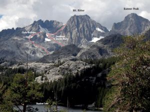
East face of Mt. Ritter
Credit: Gus Yates
bottom left corner bottom right corner
Mt. Ritter and the adjacent Banner Peak are towering hulks that dominate the skyline of the Sierras between Mammoth Mountain and Tuolumne Meadows (well, if you ignore the Minarets). All of the contemporary climbing guides and websites list only three routes on Mt. Ritter: via the Ritter-Banner col, via the southeast couloir and via class 2 talus up the west side. But the 1976 edition of Steve Roper's "Climber's Guide to the High Sierra" listed another route:

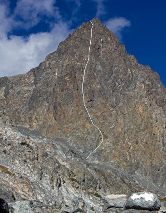
"East Face. Class 4 or 5. This route lies on the west side of Ritter's
biggest face. From the lower left side of the wall, traverse up
and right on a ledge which shoots toward a prominent scar. Wander
upward above here; there are many possible routes."

My partner Jason and I decided to check it out, and it turned out to be a fabulous climb but longer and more difficult than the description implied. The start of the climb was accurately described. The "ledge" is more like a broken-up low-angle ramp, but it went at third class. The "scar" we decided was actually the brown rectangular "birth mark" that is obvious from a distance. Above that, however, the 1976 description left a bit too much to the imagination. Sticking to the easiest rock that followed a broad, shallow chute all the way up the left side of the face, the difficulty immediately increased to 5.0-5.7 for pitch after pitch. After about 10-11 pitches, the chute bumped into a wall, but a notch on the left side put us at the base of a 70-degree slab of smooth rock (much different from the blockier climbing up to that point). The slab pitch was 5.8 (5.9 according to Jason, who fortunately led it). The route again ended in a wall, and once again, the highest exit notch on the left side miraculously connected to an easy half-pitch ledge traverse to a 3rd class gully. The gully curved up and right to a beautiful skyline notch -- except that the far side dropped off in hundreds of feet of smooth vertical rock! So we tried the same trick and checked out the nearest gap in the left side of the gully, which once again offered a way onto a half-pitch ledge traverse that brought us to 3rd class gullies near the top of the southeast couloir route.

In summary: this is a great, moderate 5th class face climb on good rock with an abundance of protection and belay station options. It makes a long day (12-14 pitches total), so move quickly. There is loose rock around, but little of it fell. Be sure to know a good way through the cliff band that blocks the approach to the base of the face (at the end of the climber's trail ascending from Lake Ediza). We wound up having to rappel down it in the dark on the descent!

  Trip Report Views: 4,001
Gus Yates
About the Author
Gus Yates is a mountain climber from Berkeley, CA.

Comments
crankster

Trad climber
No. Tahoe
  Sep 19, 2014 - 10:12pm PT
Nicely done. Venturing where few go.
Sierra Ledge Rat

Mountain climber
Old and Broken Down in Appalachia
  Sep 19, 2014 - 10:19pm PT
Spent a lot of time looking at the face and wondering......
Risk

Mountain climber
Marooned, 855 miles from Tuolumne Meadows
  Sep 19, 2014 - 11:10pm PT
Good job! You'd think that that face would get more traffic. Great to hear about it.
NutAgain!

Trad climber
https://nutagain.org
  Sep 20, 2014 - 01:20am PT
Radness! That route overview pic triggers the "I gotta climb it" urge.
survival

Big Wall climber
Terrapin Station
  Sep 20, 2014 - 04:20am PT
Nice work!!

No pictures, no pictures!!??
mtnyoung

Trad climber
Twain Harte, California
  Sep 20, 2014 - 06:34am PT
I love that kind of exploration. Nicely done.
Charlie D.

Trad climber
Western Slope, Tahoe Sierra
  Sep 20, 2014 - 07:28am PT
Great work, I wonder how much that route ever gets climbed? You're the first team I've ever heard climbing it but hey I forget what I did last week :^) TFPU and BTW any pictures?

Charlie D.
Jason Axt

Trad climber
Oakland
  Sep 20, 2014 - 08:07pm PT
No photos of the climb, although an overzealous hiker/ photographer was able to shoot a photo of Gus in his Sunday whites belaying me up from the meadow. We didn't retrieve the photo.

Note: We started from camp at Lake Ediza @ 5am and returned to camp at 9pm in early September. We left all cameras, watches, and phones at camp. Climbing never really slowed, except to figure out the route on the way up. We took a brief break for food once on the boulder field. Dark clouds threatened, but only a brief spitting of hale hit us near pitches 8 - 10.

The descent follows the class three descent from the top of Ritter through a glacier gully. Scouting the descent before will save time and headache when coming down and maneuvering the last cliff to the meadow.

If climbed earlier in the season, with good weather, a summit push should add an estimated hour to hour and a half.

Good Climb.
kaholatingtong

Trad climber
The fake McCoy from nevernever land.
  Sep 21, 2014 - 05:58am PT
i enjoyed this, a lot.
survival

Big Wall climber
Terrapin Station
  Sep 21, 2014 - 10:19am PT
We left all cameras, watches, and phones at camp.

I understand this, but when you get to my age you will wish you had pictures of things. There are at least 4-5 El Cap routes and many many others that I have no photos of.

Take a camera bro. Mine weighs probably 10 oz.
Ezra Ellis

Trad climber
North wet, and Da souf
  Sep 21, 2014 - 10:51am PT
Yeah full adventure climbing!
Go
Mt. Ritter - Southeast Glacier Route 3rd Class - High Sierra, California USA. Click to Enlarge
Mt Ritter and Banner Peak overview.
Photo: McKenzie Long