 part four: new routing at the headwaters of the kohala ditch Credit: nah000 |
||
[Click to View YouTube Video]
in case you missed the precursors part one is here, two is here and three is here
otherwise... thanks for sticking with it and here's a mood primer:
[Click to View YouTube Video]
The Kohala Ditch Trail: 36ish hrs on foot... to and from the headwaters. [4 of 5]
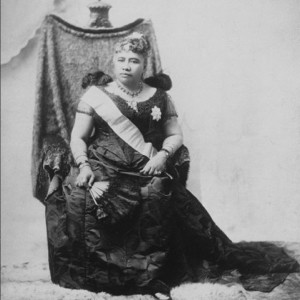
N. The Big Five + Liliʻuokalani: an oligopoly + the first queen [and last monarch] of Hawai'i
[late 1890s c.e. or about four generations ago]
 The Big Five Credit: bit.ly/2G7lTtI |
||
 Liliʻuokalani Credit: https://bit.ly/2CZJFWA |
||
The Big Five:
"The industry was tightly controlled by descendants of missionary families and other Caucasian businessmen, concentrated in corporations known in Hawaii as "The Big Five". These included Castle & Cooke, Alexander & Baldwin, C. Brewer & Co., H. Hackfeld & Co. (later named American Factors (now Amfac) and Theo H. Davies & Co., which together eventually gained control over other aspects of the Hawaiian economy including banking, warehousing, shipping, and importing. This control of commodity distribution kept Hawaiians burdened under high prices and toiling under a diminished quality of life. These businessmen had perfected the double-edged sword of a wage-earning labor force dependent upon plantation goods and services. Close ties as missionaries to the Hawaiian monarchy along with capital investments, cheap land, cheap labor, and increased global trade, allowed them to prosper. Alexander & Baldwin acquired additional sugar lands and also operated a sailing fleet between Hawai`i and the mainland; the shipping concern became American-Hawaiian Line, and later Matson. Later the sons and grandsons of the early missionaries played central roles in the overthrow of the Kingdom of Hawaii in 1893, creating a short-lived republic. In 1898, the Republic of Hawaii was annexed by the United States and became the Territory of Hawaii, aided by the lobbying of the sugar interests."
en.wikipedia.org
Liliʻuokalani and the formation of the Bureau of Agriculture and Forestry:
"So significant was the threat of these animals [introduced grazing animals including cows, goats and pigs] to the Hawaiian landscape, that on September 19, 1876, King David Kalākaua signed into law, an Act for the Protection and Preservation of Woods and Forests. By that Act, the Minister of the Interior was authorized to set apart and protect from "damage by trespass of animals or otherwise, such woods and forest lands, the property of government...best suited for the protection of water resources..." (Hawaii Laws Chapter XXX:39). The Minister of the Interior was authorized to appoint a superintendent of woods and forests:"
"...who shall, under the direction of said Minister, enforce such rules and regulations as may be established to protect and preserve such reserved woods and forest lands from trespass. Said superintendent shall have charge of the construction of fences and barriers required to protect the said woods and forest lands, and shall be responsible for their being kept in good condition... (ibid.)."
"The above Act was further defined by an Act of the Legislature of the Hawaiian Kingdom, approved by Queen Liliʻuokalani on January 4, 1893, which established the Bureau of Agriculture and Forestry. Among the Bureauʼs goals was the "preservation of forests." On June 14, 1900, the members and functions of the Bureau were absorbed by the Board of Commissioners of Agriculture and Forestry. (Hawaii State Archives - Com 2, Box 11)"
ulukau.org
Liliʻuokalani in her own words:
Before ascending the throne, for fourteen years, or since the date of my proclamation as heir apparent, my official title had been simply Liliuokalani. Thus I was proclaimed both Princess Royal and Queen. Thus it is recorded in the archives of the government to this day. The Provisional Government nor any other had enacted any change in my name. All my official acts, as well as my private letters, were issued over the signature of Liliuokalani. But when my jailers required me to sign ("Liliuokalani Dominis,") I did as they commanded. Their motive in this as in other actions was plainly to humiliate me before my people and before the world. I saw in a moment, what they did not, that, even were I not complying under the most severe and exacting duress, by this demand they had overreached themselves. There is not, and never was, within the range of my knowledge, any such a person as Liliuokalani Dominis.
Hawaii's Story by Liliuokalani
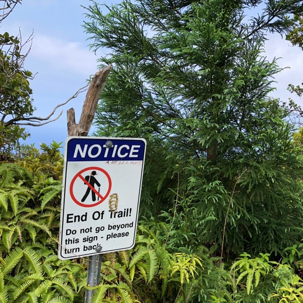
one more pig and the "end of the trail": entering the waikaloa stream valley
[16:00ish : 16.06.2018 : km 18.5ish : ~2300m gained]
[Click to View YouTube Video]
[Click to View YouTube Video]
just before i dropped into, what at the time seemed to be just one more valley, i crossed paths with my first visible wild pig. while during the trek thus far, i'd seen quite a few rustlings and minor stampedings through the grass, i hadn't actually seen one of them with my own eyes until now.
and so it was fitting that s/he even stood around long enough for me to pull out the camera.
shortly after, at the top of the slope leading down into this latest valley, there was a sign that had "End Of Trail" printed on it...
and overtop of which someone had cheekily written "A little late for that!!! with a marker.
i set a gps waypoint here, as based on the sign it looked like this would be where the going was about to get tricky again.
but the trail didn't actually end there. it was definitely more overgrown than it had been but there was still an easily followable path that really hadn't been damaged too much, so i kept working my way towards the bottom of this most recent valley.
when i arrived there i was greeted with one more dam type structure, and so what, based on gps location and old usgs maps, i later assumed/presumed must have been the very start of the kohala ditch and its original trail.
surprisingly, once i hopped across the stream i found the faintest hints of a trail that headed up the opposite side of the valley...
and so in one continuous straight line i followed a path that mostly consisted of a roughly 12-24" or so ledge carved into the side of the steep slope and that was almost completely overgrown with foliage.
very shortly after i got to the top of the ridge i once again marked my location on the gps.
O. Michael O'Shaughnessy + $694 000 [or ~$20 000 000 in 2019 dollars]: chief engineer of + total cost for construction for the kohala ditch
[1904-7 c.e. or about three and a half generations ago]
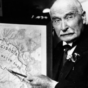 Michael OShaughnessy standing in front of a drawing inscripted with "San Francisco's 420,000 Acre Water Shed" Credit: bit.ly/2D3vWxJ |
||
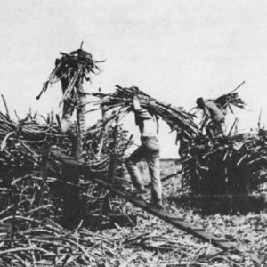 Chinese contract labourers on a Hawaiian sugar cane plantation in the late 1800s Credit: bit.ly/2I2ymkt |
||
"Sugar production needed water, an enormous amount of water. To produce a pound of sugar required up to 500 gallons of water. One million gallons was required every day for even a relatively small 100-acre plantation."
"The problem, of course, is that even though Hawaii Island usually has an abundant supply of water, it is not always in the right place. In areas such as Hilo and Hāmākua, rainfall is plentiful, though not always consistent."
"In other areas such as Kohala, however, the rain falls in the wrong places, or doesnt fall much at all. Droughts meant disaster, not only due to lack of water, but also because of the increased danger of canefield fires."
"Irrigation was the ultimate solution. Even in areas of East Hawaii where water was usually plentiful, production generally increased with regular irrigation. However, irrigation required the transportation and diversion of water, a major engineering and technological feat in the late nineteenth and early twentieth centuries. The Hawaiian sugar industry depended on moving large quantities of water over long distances through tunnels, flumes, and ditches, many of which remain in use more than a century later."
"By 1920, the sugar industry on all the islands diverted 800 million gallons of water each day and pumped an additional 400 million gallons from wells, which were especially significant on Oahu. Because these water projects did not receive support from the government, only the significant financial resources of the Big Five sugar planters, and men like California industrialist Claus Spreckels made them possible. Although small irrigation ditches existed in the 1850s, it was not until the 1870s that the large-scale construction of ditches began with Sam Alexander and Henry Baldwins Hāmākua Ditch on Maui (not to be confused with the later Hāmākua Ditch on Hawaii Island). Sprekels built a second ditch, completed in East Maui in 1879."
"Hawaii Islands ditch projects started later than the ones on other islands and benefited from the lessons learned. The need was greatest in Kohala where by 1900 five small plantations had each tried individually for several years to get more water. Their attempts resulted in small, unreliable, and easily contaminated supplies. It was clear that these independent efforts, lacking the financial resources of Alexander and Baldwin or Spreckles, were doomed. The Bishop Museum and Bishop Estate, which owned much of the watershed in the area, undertook to build an irrigation ditch that would sell water to the plantations."
"After a feasibility study suggested that the idea was both practical and profitable, two ditch companies were formed. The Kohala Ditch Company, established in 1904, was the first. The Hāmākua Ditch Company (again, not to be confused with the Hāmākua Ditch on Maui) followed in 1906."
"The five Kohala plantationsUnion Mill, Kohala Sugar, Niulii Plantation, Hālawa Plantation, and Hawi Sugarcommitted to buying water, and the Kohala Ditch Company sold stock and bonds to finance the venture."
"The chief engineer for the project was Michael OShaughnessy, an Irish-born civil engineer, who was then completing a ditch on Maui. OShaughnessy would go on to fame (or infamy) as the developer of the Hetch Hetchy water system that still delivers water to San Francisco and surrounding communities from the Sierra Nevada Mountains."
"The March 1905 Kohala contract with OShaughnessy stipulated that the ditch had to be finished in 15 months."
"Built at a relatively low cost of $694,000, the ditch returned a profit for many years, both from the sale of water and from rent obtained for land the company owned in Kohala and Hawi. In addition to making money for its investors, the irrigation resulted in nearly doubling the yield of Kohala canefields."
keolamagazine.com
sometimes the walkabout finds you: towards waimanu
[18:30ish : 16.06.2018 : km 19.5ish : ~2350m gained]
[Click to View YouTube Video]
[Click to View YouTube Video]
after chowing down on some more food, i decided to keep on heading up and out along the ridge that i had just arrived at.
and so at this point, i got to taste a bit of what the japanese contract workers would have experienced back in 1905 to 1907.
there were no longer any useful animal trails and the foliage was often up over my head. and so while there were sometimes what seemed to be pig runnels deep down under the foliage, they were more of a hazard than a help.
that's because while thrashing through the dense vegetation i'd without warning drop down into a trench... but it was so small there was no way to crawl through it... so back on top i'd work my way back out... and then soon enough i'd be crashing back through once again...
and then repeat ad infinitum.
or in my case for one hour.
thats because after an hour of continuous movement and exertion i reset my location on the gps...
and was "thrilled" to see that i had made it a grand total of about 200m since there had no longer been any remnants of a trail
huh.
while i was only about five or six kilometres from the waimanu valley, at 200m an hour i was looking at probably at least three to four full 8-12 hour days of jungle thrashing... and that was if things went smoothly.
ok... after a [very short] time spent considering my options, i made up my mind:
fuuuuhuuuuuck that.
maybe when i had been in my twenties this might have seemed worth my effort, but after having spent way too much of my life involved in manual labour, there was no serious consideration needed for the thought of that kind of noise on a "holiday"!
more importantly, even if i would have wanted to, i'd only brought four days worth of food and i'd already powered through one days worth, so the only way i would have had the reserves to keep on going would have been if the way got significantly easier further along.
and given what i was seeing, while always possible, that didn't seem like a smart gamble to take.
well... at least that decision had been easy.
and so as i had the location where i'd topped out on the ridge marked on the gps, i was relieved that all that was left was to hoof on back out to pololū
or then again, maybe not...
as i retraced my steps and arrived at the last gps waypoint i began to search for the faint trail i had exited up onto the ridge on...
but i came up empty handed.
so i headed back up the ridge towards where i'd just been at, i did my best to look intently over the side the entire way...
again: nothing.
then i turned around and thrashed back the other way, this time back towards the ocean and to a point where i was 100% certain, that i had definitely gone too far relative to my original exit point...
still no evidence of anything.
so then i tried dropping in to the sides of the valley only to work my way back out when i didn't find anything...
i did this over and over. [with the logic being given the trail had been one big long straight line contouring out of the valley i would have to hit it somewhere...]
but still... nothing.
two hours i spent doing this.
finally i was forced to accept that there weren't going to be any late night missions heading all of the way back to pololū that night.
i was out of water and exhausted from twelve hours of either hard or quickish hiking and i needed a place to both crash and get some of that much needed elixir of life... a bit of that good ole accche too oh.
and so finally i committed to heading down to the valley's bottom: at least i knew there was more water there.
given i could point the gps at the location where the end of trail sign was at on the opposite ridge and see that it was only about 400m away as the crow flies... [but also separated by the 150m or so deep and 60-90 degree steep sided valley] and that i also knew that both the path into the valley and out of the valley had been straight line contours, it seemed guaranteed that if i just picked a point between where i had reached the top and uphill on the ridge 50 or so metres from that... and then just headed on down in a straight line... that i'd hit the trail.
or at least that was the theory.
because in the end, despite following a straight line thrashing down through the jungle like covering... i still didn't find a damn thing.
and so finally with no water and with a rapidly approaching almost zero twilight, that occurs this far south, i resorted to a ski mountaineering technique i like to call tree rappelling...
the 150m or so valley side was so steep that i had to lower myself from one tree to the next... over and over.
finally as i neared the valley bottom, the trees were far enough apart along the 80-90 degree base of the valley, that there were a couple places where i had to resort to not just "rappelling" but to dropping from one tree to the next.
the first time i did this, i was super nervous as i knew it wasn't [easily] reversible.
and so finally, about four hours after i had left the bottom of the valley, i once again, and quite literally, dropped back into it.
still no trail...
and now there was a waterfall above me...
and what appeared to be one below me
but i had water and a place to sleep.
as far as how i was going to get out?
i had three more days of food to figure that out, and given my energy level in the moment: that was definitely going to have to be tomorrow's problem.
P. 35:1 + $0.08 per hr [or ~$2.30 per hr in 2019 dollars]: approximate odds of not making it out alive if you were a Japanese contract labourer on the Kohala Ditch + their approximate hourly wage
[1905-7 c.e. or about three and a half generations ago]
 A few of the Japanese contract labourers who built the Kohala Ditch Trail Credit: bit.ly/2KeWpyp |
||
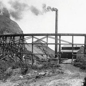 The Kohala Sugar Mill and its wooden flume in the early 1900s Credit: keolamagazine.com/then-now/kohala-ditch/ |
||
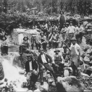
"It was an ambitious project over very rough territory. The difficult terrain ruled out the use of large equipment, meaning that most of the work would be done by manual laborers. Building wagon access trails on the edge of the Kohala cliffs was more terrifying than building the ditch itself. In some places, wagon trails were impossible, so work crews cut five-foot wide paths for pack animals."
Among the workers were 600 Japanese contract laborers, paid an average wage of one dollar per day. They could earn more by shaping rocks into square blocks, used to line the walls of some of the tunnels. For this work, still visible in the tunnels, they received five cents per block. Hand drilling by Japanese workers was cheaper than using air or electric drills to bore through the lava. It was obviously rough work. According to OShaughnessy, the Japanese seemed to like this class of work and made a success of breaking rock where other nationalities were a failure.
During construction, seventeen workers died from various causes. Many mules also died when they fell off the steep cliffs, many of them over 1,000 feet high. Even the sturdiest of workers, according to one report, were so exhausted after a few weeks of work in the dark and cold environment that they required hospitalization. To add to the difficulty, it rained nearly every day from April through July in 1905."
"Despite the difficulties, the first section of the ditch was completed in June 1906; the second portion a year later. The entire Kohala Ditch was 26 miles long, though the name ditch is somewhat misleading and possibly makes the enterprise seem simpler than it was in reality. When it went through the mountains, it consisted mainly of tunnels. There were 57 tunnels in all, the longest of which was 2,500 feet, nearly half a mile. The entire effort included 16 miles of tunnels and only six miles of open ditch. The remainder consisted of flumes, built over steep ravines and canyons. The ditch itself was lined either with cement or stones as far as Hawi; the tunnels had cement linings; and the flumes, which were seven feet wide and six feet deep, were caulked and tarred.
keolamagazine.com
a womb: at the waikaloa stream
[06:30ish : 17.06.2018 : km 19.5ish : ~2350m gained]
 a recreation of the failed night sky photo i tried to take... Credit: nah000 |
||
 and since we've got two photos or videos throughout, can't stop now! Credit: nah000 |
||
and then i immediately crashed hard.
well, almost immediately... because just before i did i was blown away by the brightness of the stars that shone down towards me and the way i felt embraced by the earth encasing me.
where i was at in the valley had a small curve to it and the walls were so steep to either side, that i was only able to see maybe fifteen per cent of the normal horizon to horizon sky... and the small remainder that i could see was in the shape of an almond that was bordered by the black silhouetted valleys at either side.
[i tried to take a few photos, but alas phones still have their limitations... so you will have to use your imagination.]
and so somehow, despite my best efforts, and in a way that i never could have planned, that night i was given exactly what i didn't know i needed.
the struggle of the preceding weeks and months, melted away... and i felt a peace that i truly couldnt recall feeling for months, maybe years at that point.
i won't try to explain exactly how or why all of this happened as ultimately i only have one point of understanding and so the answers to those questions are also up to your understandings/imaginings/intuitions...
what i will say is that the importance of that one night of healing, has been a large factor in the motivation that has pushed me to try to better understand the history of the land and spirits [known and unknown] that supported me in the way that they did that night.
Q. Hawaiian Homelands + Bill Sproat: 2.9% of the Hawaiian islands is set aside for native Hawaiian homesteaders + forty years as caretaker of the Kohala Ditch
[1921 + 1928-69 c.e. or about two to three generations ago]
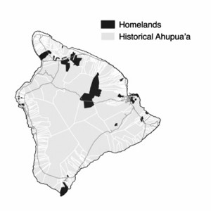 Hawai'ian Homelands on the Big Island of Hawai'i Credit: nelsonslog.wordpress.com/2016/10/26/hawaiian-homelands/ |
||
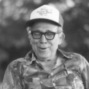 Bill Sproat Credit: apps.ksbe.edu/kaiwakiloumoku/ola-na-iwi/sproat |
||
Hawaiian Homelands:
"Upon the 1893 overthrow of the Hawaiian Kingdom, the idea for "Hawaiian Homelands" was first born. In his testimony before Congress regarding the Hawaiian Islands on January 3, 1894, William Alexander reported:"
"President Dole and his colleagues have elaborated a plan for giving the Kanakas homesteads out of the Crown lands, not transferable, and further this condition of occupation."
"In 1921, the federal government of the United States set aside approximately 200,000 acres (810 km2) in the Territory of Hawaii as a land trust for homesteading by Native Hawaiians. The law mandating this, passed by the U.S. Congress on July 9, 1921, was called the "Hawaiian Homes Commission Act" (HHCA) and, with amendments, is still in effect today. The act is often also attributed to the year 1920, when it was written. The avowed purpose of the Hawaiian Homes Commission Act was to rehabilitate Native Hawaiians, particularly in returning them to the land to maintain traditional ties to the land. The Hawaiian politicians who testified in favor of the act specifically referred to the devastation of the Hawaiian population and the loss of the land, and the need for Hawaiians to be able to grow traditional crops such as kalo (taro)."
"The Hawaiian Homes Commission Act included a controversial definition of "Native Hawaiians" as persons with 50% or more Hawaiian blood. Prince Kūhiō Kalanianaʻole, the territory's non-voting delegate to Congress, wanted a blood quantum of no less than 1 part in 32."
en.wikipedia.org
Oral History from Bill Sproat:
"Bill Sproat is 87 years old. He was born in 1903 in Pololu Valley. His father was originally from Missouri and came to Hawaii in the late 1800s after being asked by the Provisional Government Army to help over throw the Hawaiian monarchy. Bill's mother was from Pololu Valley and was Hawaiian-Spanish descent. Bill began work on the Kohala ditch trail, which belonged to the Hind Family, in 1928. Bill retired from the ditch job in 1969 as supervisor and then worked ten years for the Polynesian Cultural Center. Bill has lived much of his life in Pololu and Honokane iki Valleys and has made numerous trips into Waimanu Valley during the first half of this century."
Kim Des Rochers: So have you gone the whole length from Waimanu to Pololu?
Bill Sproat: I've been over every inch of this mountain, up and down! When you get to the end of the ditch, there's no more, when you get over to Waimanu side, there's no trail. Only a little foot trail. In fact, I was the one who made the trail because I used to work with the U.S. Geological Survey. We mapped that area in there.
KD: Besides doing some mapping for U.S.G.S. what sort of work would you do along the trail?
BS: Well, just keeping the trail open. This is the second wettest spot in the world, the Kohala mountains. And water that came from the heavens and watered the ground ... and you had a lot of rain and growth and there's a lot of that stuff that turned to soil. That's why in the bottom of these valleys there's a lot of soil. And anything would grow there. We lived in Honokane ike and we still have the lease on that place. We leased that valley from the Bishop Estate. And when the Japanese came and wanted to lease all this place they wouldn't give them the valley. They givethe valley to us. I raised all my kids in there. Luckily I had a wife that was a nurse so I didn't have to worry about my kids. She was a professional nurse.
KD: What was the condition of the trail in those days, say between Waipio and Waimanu?
BS: The trail was good, you could ride a mule. But not on this side. No trail from here. We were the only ones out there. We didn't need to go, I went more for curiosity. Then I took the u.S. Geological Society out to map all this mountain. They didn't even have a map for the mountain. Nobody else was that curious about the area I guess.
KD: In your time, did a lot of people go back and forth between Waimanu and Waipio?
BS: Oh yeah, when people lived there. Easy enough to go. Too bad you come here so late. You should have come here when old Kahikina was living in Honopue.
KD: What was his name?
BS: Kahikina.
KD: And he was an old Hawaiian living there?
BS: He had a whole settlement in there. He had several houses all grass houses. All grass and ti. They put it on like shingles.
KD: So this man, did he live with his family or was this a whole community of people?
BS: Oh yeah, yeah. Kahele. He raised a guy named Kahele. We called him Wawaekekake meaning jackass feet. Because he was born without the front part of his feet. He had only the heel.
KD: How could he walk?
BS: You'd be surprised! That guy walked all over this mountain.
KD: Really? With crutches?
BS: Just walking. He carried a stick too as a cane. Kahele was his name.
KD: Is there anything else you can think of about Waimanu that's special or worth mentioning, like legends?
BS: Back then, at night when you stayed with these old folks, that's all they do is tell stories. Because you had no T.V. or radio or anything like that and they tell stories at night. But you had to know Hawaiian, they [the stories] were all in Hawaiian. They couldn't speak English a lot of these old guys.
KD: What about your father, where was he from?
BS: Missouri.
KD: Oh, he was a Mainlander.
BS: Yeah. He came in to help to overthrow the monarchy.
KD: Oh really!
BS: But the monarchy overthrew him! But actually, I asked him how in the world he ever came here. He said he left home. See, his folks settled Pennsylvania. Then they moved west and settled in Missouri. That's where he was born. He was the last in the family; eight of them in the family. Five girls and three boys. When he grew up he left home and he came west and I asked him how he ever came here. He said he came west because what he was going to do was he was going to come west get on a ship and go to Alaska and to look for some of the gold because they discovered gold in Alaska. That's where he was headed for. He said, when he got to San Francisco was walking along the waterfront looking for a ship to go to Alaska, he said two men came up to him and asked him if he wanted to join the P .G. Army, the Provisional Government that overthrew the monarchy. These were the white men that came here as missionaries, and these were their sons. They were going to take the islands away from the Hawaiians. Because Queen Lioukalani didn't agree with the things they were doing, see. So he came here, and when he found out what they were up to, he said" No, to heck with you guys. Now you come here and you want to take the land away from the people that own it. We Americans don't believe in things like that!" So he got out of the army. He wouldn't go along with them. He and another guy - who was another farm boy like him - a farmer from Missouri, they bought themselves a schooner. They wanted to go to the South Seas. They hired an old sea captain, retired. They paid him to sail the boat to Tahiti for them. They started for Tahiti ... they were out almost crossing the equator when a hurricane came up and hit them wrecked the boat. Broke both masts and they just drifted for days and finally they drifted clean back and wrecked on the Kona coast.
KD: When you worked on the trail, who were you working for exactly?
BS: It belonged to the Hind Family. And they owned the plantation out here. They needed the water to water their cane. So the ditch was quite a job too. It comes all the way from the mountain travels miles in the mountains, then it comes out here and from the valley over here all the way to Hawi. All time built on 1/10 of 1 % grade. And there's more to it than you think. You go there and you see some places where those valleys are deep and they built flumes across there. I was in charge of that too for some years so I know every inch of the ditch. And that tunnel is built on 1/10 of 1% grade, almost a flat grade. But when you put 50 million gallons a day, coming through that tunnel, that's a pretty fast current coming through there. You can't walk up against it when you're bringing down 50 million gallons. You got to cut it down to 30, 35 million gallons about waist deep. Then, when you push a boat up through the tunnel, you walk in the eddy that's formed by the boat with a flat bottom. They take all the heavy stuff up through the tunnel on the boat. And stuff that you can carryon the mule, you carryon the mule. I was working on the boats going to the Mainland, but they came and got me to take my dad's place. They couldn't find anybody who knew the mountain. So they came looking for me. By that time I was just going to quit the boats anyhow because I met my wife. She was a Rodenhurst [wife's maiden name], see. Her mother was Hawaiian. And we had decided to get married. She had her training at Children's Hospital in Honolulu. She knew how to take care of kids. I never had a sick kid in my house
KD: If I'm in Waimanu and I want to walk to the next valley over, where do I start the hike ... going towards Pololu?
BS: When you get down to Waimanu it drops straight down, maybe 75 or 80 feet to the bottom. So what I did was I stretched a wire across there and had it go down with a little runner.
KD: Was this on the Kohala side of the valley?
BS: Kohala side. This side, no trail. But then again, there's another way. There's a beach that goes along the base of this cliff and you could walk.
KD: What's a good time of the year to do that?
BS: Summer time. Because you have longer days in the summer time and you have less rain in the summertime and you have a calmer ocean because you don't have the winds like you have in the winter months. When you go there, you have to check that your low time so that low tide is in the morning. So you don't have high tide. It's been so long since I've been over there, but I heard that there's one part there the landslide
came down for a couple hundred yards. Blocked off the trail at the base of the cliffs.
KD: Laupahoehoe iki.
Waimanu Valley Oral History Report
new routing jungle alpinism style: in the waikaloa valley
[10:00ish : 17.06.2018 : km 20.5ish : ~2550m gained]
[Click to View YouTube Video]
[Click to View YouTube Video]
alright.
tomorrow's problem, had now become... today's problem!
being a climber and given it was only 20' or so high, the waterfall that was between me and what i assumed had to be where the trail crossed the stream... should have been easy to get past/around somehow right?
no dice. climbed as much and as high as i dared, but the moss covered rock and limited foliage that wasn't strong enough to grab onto, meant that heading directly up and/or to the sides of it was a no go for me...
so i checked out downstream of me, even though it was in the opposite direction of where i needed to go in order to regain the trail...
and yup: stymied by another waterfall...
which left only two options: heading up the way i had come down the night before, or as i knew where, on the pololū side of the valley, the sign had been and that that was significantly downstream of me, maybe i could climb my way back out that side of the valley and likely hit the trail on my way up and out?
well, i'll forgo the words to describe that attempt and leave it to you to watch the video for yourself.
short is, again i pushed it as long and as far as i felt comfortable...
and still no trail.
and so i had no choice: i was going to have to go back up and out towards the waimanu side, once again in the opposite direction from where i needed to head...
and so back up towards the ridge that i had already spent hours trying to find the trail on, with no success...
but first, you remember that tree rappelling i mentioned? or more precisely the tree to tree dropping? i was now going to have to figure out how to reverse what had been a bit disconcerting when i had first committed to it...
so i tried one way...
and then another...
and then finally after a bunch more upping and downing and just about at the same time that i was starting to lose hope that that side was going to go, i was finally able to succeed in working my way through a crux [given the unlikelihood of a repeat i'll spoil the beta: it involved a v3 or so stem between a 2" or so tree and the cliff, to an above the head heel hook up to the next tree... good thing i had been bouldering at the gym recently ha!]
as far as the rest of the way up? again, if you are interested, i'll leave the video to mostly speak for itself [even though it's hard to tell from the video how challenging it was ]
for the most part the up and out involved 45 to 60 degree fern pulling with my hands while also relying on a lot of ice climbing technique, as i resorted to alot of kick stepping into the roots, dirt and undergrowth trying to find purchase for my feet.
finally i was back out to the ridge.
and back to repeating similar thrashings as the day before...
and so as i began to employ the same strategy of repeatedly dropping over the side for 10-20' and then reclimbing back out
i abruptly came face to face with what appeared to be an old pair of pants and a partially decayed set of long underwear hanging in some dense undergrowth...
hmmmm
part five is now posted here