East Face, Mt. Whitney 5.7 |
||
High Sierra, California USA | ||
| ||
|
Avg time to climb route: 4-8 hours
Approach time: 3-6 hours Descent time: 3-6 hours Number of pitches: 13 Height of route: 1000' Overview
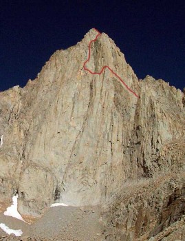
At first glance the 1,800-foot east face of Mt. Whitney appears much too difficult for a 5.7 route. Luckily, looks are deceiving and the face has just enough weaknesses that are connected in just the right ways to make the climbing mostly moderate and incredibly fun. The exposure and commitment on this climb are intense making the route only suitable for experienced 5.7 leaders. The East Face is included in Steve Roper and Allen Steck’s “50 Classic Climbs of North America,” giving the route additional appeal and popularity. Most climbers are usually torn between whether to climb the East Face or East Buttress, as both are classic routes. The East Buttress is more sustained and a more direct line but the East Face has more variety and a richer history. Both routes are about the same difficulty. Photos
- View all 14 photos of East Face as: Thumbnails | Slideshow
Climber Beta on East Face
Which SuperTopo guidebooks include a topo for East Face?
Find other routes like
East Face
Everything You Need to Know About
High Sierra
Search the internet for beta on
East Face
Links to related internet pages with info on East Face
|
Other Routes on Mt. Whitney
|


