Dirty Baggins
Trad climber
monterey
|
 |
Beware of the loose jug halfway up the second pitch. I found doubles of smaller cams useful. We made an easy traverse right to Plutonics and made three 60m double rope rappells to a ledge and easily down climbed ten feet to the ground.
|
Chris Brent
Trad climber
San Francisco
|
|
The trail is really easy to find and well marked. Great route, although if you're going early to beat the crowds you might want to wait until the sun gets on it if the temps are low and the wind is blowing. We got cold until the sun hit us on pitch three.
Someone took a dump on the second belay ledge, before the double cracks. Not very cool.
|
dylan
Trad climber
Berkeley
|
|
Approach trail is very easy to follow - starts at the road at:
37 deg 51' 18" N
119 deg 26' 21'' W
Look for the cairn - follow the trail/cairns. Turn right when you get to the wall to find Holdless.
This climb is beautiful. Lovely views of Tenaya lake from the 3rd belay. Crack takes pro easily (tons of nuts).
-D
|
Chugar
Trad climber
Mariposa, CA
|
|
The approach path is well-defined now. It looks just like a normal hiking trail.
The steeper sections of climbing was really nice and fairly protectable. However, the low angle 4th class wasn't too fun as it put a strain on your heel/achilles tendon.
The walkoff the backside was a pain. Not as long as Cathedral or Tenaya but not as short as Lembert. Once you get into the treeline, the trail is barely noticeable.
Also, the new Supertopo edition has many more routes at Dozier so there were a few people there already.
|
Melissa
Gym climber
berkeley, ca
|
|
There is a crack to the right of Holdless Horror that, IMO, is just as good. It's not in any guide that I've seen. I'd say the crux is a tiny notch harder (5.7), but it's got great pro. The crack system is basically unbroken from bottom to top.
There are lots of new face climbs in the vicinity as well for which I've got no info.
|
George R
climber
The Gray Area
|
|
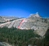
DOZIER DOME APPROACH (20 minutes):
A good use trail is appearing. Please try to follow this trail and avoid creating more unnecessary trails.
The Dozier Dome trail starts about 5 1/2 miles west of the Tuolumne Meadows Store. At a little over 5 miles west of the store, you'll pass a paved turn-out on the left (parking for Low Profile Dome). Dozier parking is 2/10 mile beyond this paved turn-out (or 1.3 miles east of Tenaya Lake parking lot) at a low road cut. You can park on either side of the highway, but the south side has more room.
Pick up a climbers' path which heads into the woods and crosses the Park Service trail paralleling the highway. The main Dozier trail starts from an area of open rock slab which is adjacent to the Park Service hiking trail. (You can park elsewhere along the road then go a short way through the woods to the NPS trail. Once on the NPS trail, go toward the open slab, turning right or left on the trail depending upon where you parked in relation to the above reference point).
From the Park Service trail, head up the open slab toward the Dome. About 100 yards up the slab, turn right to pick up the climbers' trail. The trail is easy to follow from here.
A short way from the slabs, the trail turns left and heads up through the woods toward Dozier Dome.
Just before the swamp, the trail turns right. It bypasses the end of the swamp, then heads back left and meanders up through the woods.
The trail exits onto the very large upper slabs. Cross the slabs, roughly paralleling the Dome.
The final leg is a trail going up through woods to the base of Dozier Dome. It starts at the far side of the open slabs.
|
Gunkie
Trad climber
Valles Marineris
|
|
We did the route in July 2005. Fun climb that follows an obvious crack for a few pitches of surprisingly low angle climbing. I opened my pack up at the base and realized I forgot my climbing shoes at the car. Did it in my floppy approach shoes and had no difficulty as these things melded into the knobby crack. The walk-off around to the right was more intimidating. Though, we may have gone the wrong way.
|
harmonydoc
Trad climber
Rohnert Park, CA
|
|
Climbed this September 10th, 2005. I only started leading this summer, but the route felt well within my comfort zone (generally 5.6) - well protected, moves never felt tenuous or required much upper body strength. Got in the offwith with my legs, felt very secure. Crux protected nicely with 3.5 Camalot. Brought a #5 Camalot C4, it just got in my way - I didn't need anything bigger than the 3.5. Placed several hexes and large nuts. Overall a very fun climb! Getting there took us about 45 minutes and some wandering through the trees. Due to various factors we didn't top out until dusk - it's VERY dark once the sun sets, the landmarks are all gone. Once we got off the dome into the forest we got turned around in the dark and couldn't find the road. Thankfully we were dressed pretty warmly and I had brought matches, so what could have been life-threatening (the low was 17 degrees that night) was merely an uncomfortable adventure spent huddled around the fire. Next time I'll bring a compass, too!
|
Floyd Hayes
Trad climber
Hidden Valley Lake, CA
|
|
I climbed it with two relatively inexperienced teenagers on Sunday, September 4. The approach took us only half an hour, despite having wandered too far north toward Medlicott Dome. We didn't see any cairns and there were no mosquitoes. We started climbing at 8:30 when it was very chilly, so the teens had to stop frequently to warm up their numb hands (I would not recommend an early morning start) and we were uncomfortably cold until the sun hit us on the last pitch. The climb took us 4 hours. It reminded me a bit of the Regular Route on Fairview Dome, but was easier, wider in places and more gnarly. In a few places it felt more like 5.7, which was the original rating I believe, rather than 5.6. The cracks eat up protection so running it out is never necessary. Nuts and cams worked fine; I had only one large hex. A large cam was conveniently fixed in one of the crux wide sections of the second pitch. The SuperTopo guide shows the second belay at a third ledge, but we belayed at the first ledge which appeared to be slightly more spacious than the third. Our third belay was at a small ledge just below the old fixed pin shown in the SuperTopo guide. The descent from the boulder at the "summit" took us 45 minutes. We descended behind the "dome" to a lake and criss-crossed a stream down class 2 and 3 slabs to the forest. We then traversed diagonally cross-country toward the road, trying to aim halfway between Pywiack and Medlicott Dome and directly away from Dozier Dome, and diagonalled up and down a ridge before arriving at the road about 100 yards from our car. In retrospect it would have been useful to memorize landmarks on the west side of the road to help guide ourselves back.
|
thedeuce
climber
Santa Cruz, CA
|
|
I was there the first weekend of October. The weather was stellar and the cliff was deserted. I think that the approach is slightly faster than the hour given in the book. The trail to the dome is very well marked with cairns and easy to follow. The topo isn't kidding when it says "hexes useful" - I recommend bringing a full set. All in all this is a very enjoyable route.
|
*What is "Route Beta"?
It's climber slang for information or tips on a route as in, "what's
the beta on that route?" As a service to fellow climbers we ask SuperTopo
guidebook users to post tips and updates to this website if they have relevant
information to share after a climb.
| | | | | | | | | | |