Eagle Dance, Eagle Wall 5.10c A0 |
||
Red Rocks, Nevada USA | ||
|
Google Maps Overview
|
|
|
A map of the general Red Rocks, Nevada USA area is shown below. No GPS coordinates for this specific route are available at this time. Approach
The approach to the Eagle Wall is straightforward, but extremely long because most of it involves scrambling over boulders. Hike the trail to the Solar Slab area and dive down into the canyon bottom when the bench ends about 200 yards past Solar Slab. Hike up the canyon, then up the north fork when the canyon divides. This is the only place you could get off route, so keep an eye out for the north fork/south fork split. Head up the north fork for a long while, looking for two HUGE pine trees in the middle of the drainage. From the right (north) tree, head up slick 3rd class slabs, and contour right along the easiest way up the slabs. After about 20 minutes youll reach the main wall and downclimb a 60-foot 3rd/4th class gully, then continue up for 5 minutes to the base of the Eagle Wall. Eagle Dance starts in a small black dihedral about 50 feet right of a large detached pillar. Levitation 29 starts 50 feet right of Eagle Dance, with a few bolts visible not far off the deck, and heads through a roof 150 feet up. Ringtail starts 100 yards right of Levitation 29 in left-angling cracks about 50 feet before the huge drop off into the Painted Bowl.Descent
Rappel the route. A final pitch of low-angle crack to face with four old bolts leads to the top, and a LONG journey up canyon and back down the drainage will take most people who have not done it in the range of 4 or more hours. |
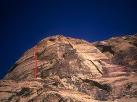 Photo: Greg Barnes
|
Home | Climbing Areas | Free
Topos | Guidebooks | Route
Beta | Forum | Trip Reports |
Photos | Articles
Links | Terms | Privacy | FAQ | Contact
| About Us
Climbing Areas
Rock Climbing Yosemite |
Big Wall Rock Climbing Yosemite |
Rock Climbing Tuolumne |
Rock Climbing Sierra
Rock Climbing Red Rocks |
Rock Climbing Southwest |
Rock Climbing Zion |
Rock Climbing Tahoe |
Climbing Alaska
All trademarks property of their respective owners
How can we improve SuperTopo? Got feedback?
![]() Let us know!
Let us know!
Climbing is dangerous. Climb at your own risk.