Frogland, Whiskey Peak 5.8 |
||
Red Rocks, Nevada USA | ||
|
Google Maps Overview
|
|
|
A map of the general Red Rocks, Nevada USA area is shown below. No GPS coordinates for this specific route are available at this time. Approach
Accessed by an independent dirt road far from the gated loop road, Black Velvet Canyon is an easy and convenient area to approach. The obvious trail heads up from the parking area toward the mouth of the canyon. After a gentle climb, the trail splitsone branch dives down into the creek bed and continues up the canyon and to Black Velvet Wall and the other goes steeply up left to Frogland.The trail bypasses a small cliff band to the left, then contours right through brush to the base of the route, which starts at a 30-foot-tall white flake at the base of a big, brown left-facing corner. The approach takes about 30 minutes. Descent
The descent for Frogland is simple and requires no rappels, yet the gully is loose and has a few short 3rd class downclimbs. Luckily, huge cairns guide you down the correct parts of the gully, and even if you make a mistake, it is easy to backtrack. Once back at the level of the base, a well-worn trail works back to Frogland. You can cut down early if you didnt leave anything at the base, but the best trail by far is the approach trail, so look out for it. The descent takes about an hour, depending on how fast you travel down rocky gullies.
|
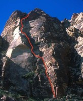 Photo: Greg Barnes
|
Home | Climbing Areas | Free
Topos | Guidebooks | Route
Beta | Forum | Trip Reports |
Photos | Articles
Links | Terms | Privacy | FAQ | Contact
| About Us
Climbing Areas
Rock Climbing Yosemite |
Big Wall Rock Climbing Yosemite |
Rock Climbing Tuolumne |
Rock Climbing Sierra
Rock Climbing Red Rocks |
Rock Climbing Southwest |
Rock Climbing Zion |
Rock Climbing Tahoe |
Climbing Alaska
All trademarks property of their respective owners
How can we improve SuperTopo? Got feedback?
![]() Let us know!
Let us know!
Climbing is dangerous. Climb at your own risk.